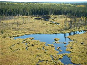


Aquatic Habitats in the Lower Athabasca Region: Wetlands
Wetlands are areas where the water table is at or near the surface, or where the land is covered by shallow water for long enough to result in water tolerant vegetation and altered soils (Environment Canada 2006). Wetlands are neither truly terrestrial nor truly aquatic, and are often transition zones linking land and water environments. Wetland characteristics are determined by climate, topography and landscape, soils and geology, hydrology, vegetation, and human impacts.
In Alberta, wetlands are classified into five categories, differentiated along gradients of hydrologic, chemical, and biological gradients as follows (Halsey 1999, Environment Canada 2006):
- Shallow Open Waters, wetlands that are covered by water less than 2 m deep at midsummer. Shallow open water wetlands are transitional between saturated or seasonally wet ecosystems and truly aquatic ecosystems such as lakes.
- Marshes, open wetlands that periodically retain shallow surface water, with levels fluctuating due to the influence of surface water, groundwater, precipitation, and seepage. Marsh vegetation can include rushes, reeds, grasses, sedges, shrubs, and emergent, submerged, and floating macrophytes.
- Swamps are forested, wooded, or shrubby wetlands. While not as wet as marshes, fens, and open bogs, swamps exhibit strong seasonal water level fluctuations.
- Bogs are peatlands that receive surface water only from precipitation and have low water flow, with water tables generally 40 to 60 cm below the peat surface. Bogs are acidic, and may be open, wooded, or forested.
- Fens are peatlands with a fluctuating water table at or near the peat surface. Fens are similar to bogs, but support marshy vegetation and a greater diversity of plant species.
Wetlands can develop into peatlands, or muskeg, through the deposition of organic debris (peat) over time. Peatlands develop as a result of stabilized seasonal water levels and restricted water flows, and anaerobic conditions and decreased nutrient availability that result from the establishment of a moss layer. These factors lead to a decrease in decomposition rates; the low rate of decomposition relative to peat production leads to the accumulation of peat over time. Peatlands within the boreal forest region of northern Alberta account for approximately 90% of Alberta’s 114,000 km2 of wetlands.