


Water Quality
Water quality is dependent on the characteristics of the surrounding landscape and climate, in-stream processes, and natural and human inputs, and is a key component of aquatic habitat. Water quality is monitored by RAMP to better understand the natural water chemistry of the Athabasca oil sands region and to identify potential impacts on water quality that may result from development.
The specific objectives of the RAMP Water Quality component are to:
- Collect data that can be used to characterize natural variability in water quality throughout the region, assess water quality predictions found in oil sands EIAs, and meet the monitoring requirements found in regulatory approvals.
- Monitor changes in water quality that may indicate chemical inputs from point or non-point sources.
- Assess the suitability of waterbodies to support aquatic life.
- Provide data to support interpretation of RAMP biological surveys (i.e., fish and benthic invertebrate components).
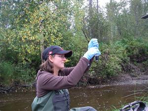
Water quality samples are collected at stations on rivers, streams, and lakes throughout the RAMP study area (see map to the right). Multiple stations may be located on the same river or stream in order to assess gradients of change in water quality along a river, or differences in water quality between stations located upstream and downstream of oil sands developments. RAMP attempts to collect at least three years of baseline data at stations of interest before development occurs, in order to facilitate comparison of post-development water quality with natural conditions and variability in water quality. RAMP water quality sampling occurs in each season, although most samples are collected in fall, when rivers and lakes are still free from ice and river flows are relatively low.
Water quality samples are submitted to analytical laboratories for measurement of the following variables:
- Conventional variables—colour, dissolved organic carbon (DOC), pH, specific conductance, total alkalinity, total dissolved solids (TDS), total hardness, total organic carbon (TOC), and total suspended sediments (TSS);
- Major ions—bicarbonate, calcium, carbonate, chloride, magnesium, potassium, sodium, sulphate, and sulphide;
- Nutrients—nitrate+nitrite, ammonia, total Kjeldahl nitrogen (TKN), and total and dissolved phosphorus;
- Biological oxygen demand;
- Organics—naphthenic acids, total phenolics, CCME hydrocarbons, and PAHs; and
- Total and dissolved metals.
Toxicity is also measured at select stations in each year, while chlorophyll-a is measured in samples from lakes. Alberta Environment and oil sands operators also collect water quality data in the oil sands region; these data are integrated into the RAMP database for inclusion in analysis.
The analysis of water quality data focuses on key measurement endpoints (i.e., specific water quality variables) that have been identified as significant in oil sands EIAs, of special concern or interest in the oil sands region, or of significance to other RAMP components. The key measurement endpoints and reasons for their significance include:
- pH: an indicator of acidity;
- Conductivity: an indicator of overall ion concentration;
- Total suspended solids (TSS): a variable strongly associated with several other measured water quality variables, including total phosphorus, total aluminum and numerous other metals;
- Dissolved phosphorus, total nitrogen and nitrate+nitrite: indicators of nutrient status;
- Various ions (sodium, chloride, calcium, magnesium, sulphate): indicators of ion balance, which could be affected by discharges or seepages from focal projects or by changes in the water table that lead to changes in the relative influence of groundwater;
- Total alkalinity: an indicator of the buffering capacity and acid‑sensitivity of waters;
- Total dissolved solids (TDS) and dissolved organic carbon (DOC): indicators of total ion concentrations and dissolved organic matter (particularly humic acids), respectively;
- Total and dissolved aluminum: variables of interest identified in some oil sands EIAs and by other sources due to potential toxicity to aquatic organisms;
- Total boron, total molybdenum, total strontium: three metals found in predominantly dissolved form in waters of the RAMP study area that may therefore be indicators of groundwater influence in surface waters;
- Total arsenic and total mercury (ultra-trace): metals of potential importance to the health of aquatic life and human health, which may originate from natural and anthropogenic sources; and
- Naphthenic acids: relatively labile hydrocarbons associated with oil sands deposits and processing that have been identified as a potential toxicity concern.
Water quality data are analyzed by comparing measured concentrations to water quality guidelines for the protection of freshwater aquatic life, and to historical or pre-development concentrations measured at the same location. Changes in water quality are identified by comparing concentrations of water quality measurement endpoints to the range of natural concentrations, defined by pooling all baseline concentrations for each endpoint from comparable stations.
For additional information on the collection and analysis of water quality samples and the analytical approach used for assessing water quality data, please refer to the relevant sections of the RAMP Technical Design and Rationale document and annual RAMP technical reports (see Monitoring Results). For more general information on water quality, visit the Water and Sediment Quality module.