


Firebag River Hydrological Profile
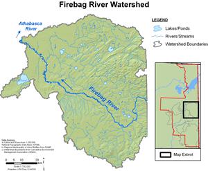
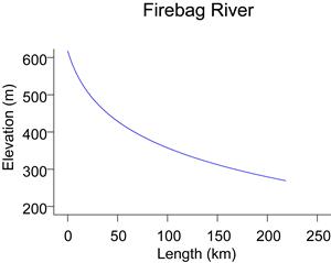
The Firebag River drains a 5,990 km² area that extends into Saskatchewan and includes the northeast slopes of Muskeg Mountain. From an upper elevation of approximately 580 m, the Firebag River descends over its course and empties into the Athabasca River from the east, approximately 100 km upstream of the Athabasca delta. Flows for the Firebag River near the mouth are recorded by WSC (station 07DC001) from March to October and by RAMP (station S27) from October to March.
Online Hydrographs
View online hydrographs of the Firebag River in the Interactive Features section.