


Steepbank River Hydrological Profile
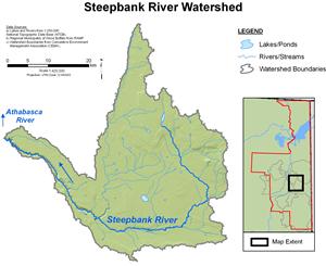
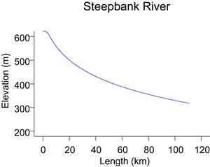
The Steepbank River originates on the south slopes of Muskeg Mountain at an elevation of approximately 580 m, and drains an area of about 1,350 km² before it reaches the Athabasca River approximately 40 km downstream of Fort McMurray. The Steepbank River watershed includes areas of plateau and the south slopes of Muskeg Mountain, with about 45% of the watershed considered upland and 55% lowland area. As its name implies, the lower reaches of the river are characterized by steep valley walls.
Flows for the Steepbank River near Fort McMurray have been recorded by WSC since 1974 (station 07DA006). For some years, data are available on a continuous basis (throughout the year) and other years data are only available seasonally (March through October). Recorded flow records show that spring snowmelt from the south facing slopes of Muskeg Mountain can cause flows to rise rapidly in the spring. Maximum flows generally occur at this time or later in the summer or early autumn due to precipitation events. Lowest flows generally occur in the winter, when precipitation is stored as snow, or in late summer when dry conditions can prevail. The highest recorded flow of 81 m³/s occurred on May 8, 1985 and the lowest recorded flow of 0.022 m³/s occurred on September 18, 1981.
Online Hydrographs
View online hydrographs of the Steepbank River in the Interactive Features section.