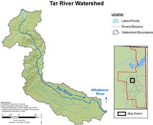


Tar River Hydrological Profile
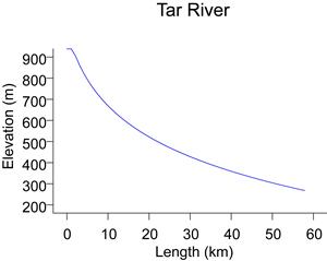
The Tar River collects water from the southeast slopes of the Birch Mountains, with a headwater elevation of approximately 810 m. In its lower reaches, the Tar River historically meandered through a muskeg-dominated landscape until it reaches the Athabasca River from the west at an elevation of approximately 230 m. The drainage area of the Tar River is 333 km². Flows for the Tar River are recorded by RAMP (station S15 and S15A; Tar River near the mouth and station S34; Tar River above the Canadian Natural compensation lake) and were previously recorded by WSC (station 07DA0150).
In 2004, Canadian Natural was granted DFO authorization to divert the lower reaches of the Tar River in response to the development of the Horizon Oil Sands Project. To compensate for the loss of fisheries habitat from the Tar River, a No Net Loss Plan was developed and approved by DFO. The plan involved the construction of a 76.7 ha compensation lake and the eventual diversion of flows from the Tar River to the Calumet River watershed, planned for 2018. Construction of the Tar River dam was initiated in 2006, and the compensation lake filled in the spring of 2008. Water now leaves the compensation lake and flows down an eight kilometre diversion ditch, returning to the lower reach of the original river system.
Online Hydrographs
View online hydrographs of the Tar River in the Interactive Features section.