


Hangingstone River Hydrological Profile
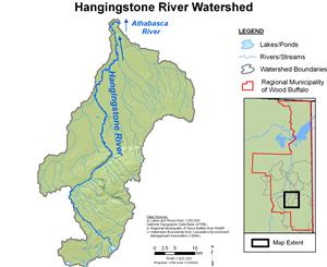
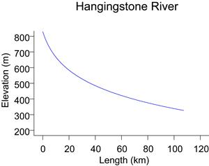
The Hangingstone River drains an area of 1,070 km², and flows into the Clearwater River just upstream of the Athabasca River at Fort McMurray. The landscape of the Hangingstone River drainage basin is dominated by muskeg. The headwaters of the river are located an an elevation of approximately 720 m.
Flows for the Hangingstone River at Fort McMurray have been recorded by the Water Survey of Canada since 1970 (WSC station 07CD004). Minimum discharges generally occur in the winter, with records indicating periods without flow. The Hangingstone River generally experiences high flows in the spring during snowmelt, with peak flows possible in the summer and fall caused by precipitation events. The WSC maximum recorded daily flow of 135 m³/s occurred on July 2, 1970. Ice jams on the Hangingstone River near Fort McMurray can occur during spring ice break-up and can result in high water levels and potential flooding.
Online Hydrographs
View online hydrographs of the Hangingstone River in the Interactive Features section.